
NASA’s Terra satellite passed over the Gulf of Mexico early on Aug. 25 and found a very small area of convection from post-tropical cyclone Marco, northeast of its center.
NASA’s Terra satellite passed over the Gulf of Mexico early on Aug. 25 and found a very small area of convection from post-tropical cyclone Marco, northeast of its center. All watches and warnings have been dropped as the storm continues to weaken toward dissipation.
Visible imagery and surface observations indicated that Marco made landfall around 7 p.m. EDT on Aug. 24 near the mouth of the Mississippi River. The center continued to move west and moved offshore and south of Louisiana by Aug. 25.
NASA’s Terra Satellite Reveals Effects of Wind Shear
NASA’s Terra satellite uses infrared light to analyze the strength of storms by providing temperature information about the system’s clouds. The strongest thunderstorms that reach high into the atmosphere have the coldest cloud top temperatures.
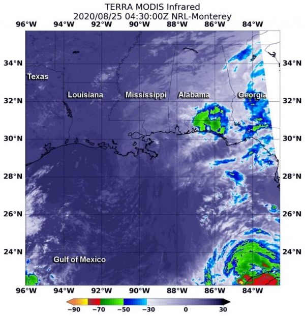
On Aug. 25 at 12:30 a.m. EDT (0430 UTC), the Moderate Resolution Imaging Spectroradiometer or MODIS instrument that flies aboard NASA’s Terra satellite observed Marco in infrared light and found a small area of storms where cloud top temperatures as cold as minus 50 degrees Fahrenheit (minus 45.5 Celsius) over the western Florida Panhandle and coastal Alabama. Those storms were being pushed northeast of Marco’s center from southwesterly wind shear. Satellite imagery also shows the low-level circulation center was a swirl of clouds south of Louisiana, over the Gulf of Mexico.
Read more at NASA / Goddard Space Flight Center
Image: On Aug. 25 at 12:30 a.m. EDT (0430 UTC), the MODIS instrument that flies aboard NASA’s Terra satellite gathered infrared data on post-tropical cyclone Marco that showed a small area of storms where cloud top temperatures were as cold as minus 50 degrees Fahrenheit (minus 45.5 Celsius). Credit: NASA/NRL


