
The 2020 Atlantic hurricane season has broken many records so far, and the season still has two months to go.
The 2020 Atlantic hurricane season has broken many records so far, and the season is barely half done. More named storms have occurred earlier than ever before in the satellite era. As of September 14, the National Hurricane Center had named twenty storms in just over three months; an average season produces twelve storms in six months.
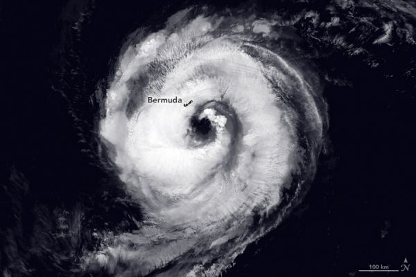
Five tropical storm systems were swirling in the Atlantic Ocean on September 14, tying the record for the most tropical cyclones observed in the basin at one time. Hurricane season typically peaks from mid-August to late October.
The image above shows the strongest of the five current storms, Hurricane Paulette. On the morning of September 14, the eye of the hurricane passed directly over Bermuda with maximum sustained winds of 150 kilometers (90 miles) per hour. The Visible Infrared Imaging Radiometer Suite (VIIRS) on the Suomi NPP satellite acquired this image of Hurricane Paulette at 2:30 a.m. Atlantic Daylight Time on September 14, 2020, just hours before the storm reached the island. Clouds are shown in infrared using brightness temperature data, which is useful for distinguishing cooler cloud structures from the warmer surface below.
Continue reading at NASA Earth Observatory
Image via NASA Earth Observatory


