
NASA-NOAA’s Suomi NPP satellite provided an infrared image of Post-tropical cyclone Teddy over the province of Newfoundland, Canada in the early morning hours of Sept. 24.
NASA-NOAA’s Suomi NPP satellite provided an infrared image of Post-tropical cyclone Teddy over the province of Newfoundland, Canada in the early morning hours of Sept. 24.
Teddy’s Last Advisory
At 11 p.m. EDT on Sept. 23 (0300 UTC on Sept. 24), NOAA’s National Hurricane Center (NHC) issued the final advisory on Post-Tropical Cyclone Teddy. At that time, the center of Post-Tropical Cyclone Teddy was located near latitude 51.0 degrees north and longitude 57.3 degrees west based on the Marble Mountain, Newfoundland, radar and surface observations along the west coast of Newfoundland. The post-tropical cyclone was moving toward the north-northeast near 32 mph (52 kph), and this general motion is expected to continue through Thursday. Maximum sustained winds were near 50 mph (85 kph) with higher gusts. The estimated minimum central pressure is 975 millibars.
The center of Teddy moved closer to the northwestern Newfoundland coast overnight.
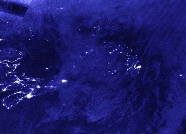
NASA’s Night-Time View
The Visible Infrared Imaging Radiometer Suite (VIIRS) instrument aboard Suomi NPP provided a nighttime image of Post-Tropical Storm Teddy over Newfoundland, Canada. The image was taken at 1:40 a.m. EDT (0540 UTC) on Sept. 24. The nighttime lights of Newfoundland can be seen somewhat through Teddy’s clouds, and the nighttime lights of Nova Scotia were visible, revealing that Teddy had moved past the province.
Read more at NASA/Goddard Space Flight Center
Image: NASA-NOAA’s Suomi NPP satellite provided a nighttime view of Post-Tropical Cyclone Teddy over Newfoundland, Canada at 1:40 a.m. EDT (0540 UTC) on Sept. 24. The nighttime lights of Newfoundland can be seen somewhat through Teddy’s clouds, and the nighttime lights of Nova Scotia were visible, revealing the Teddy had moved past the province. (Credit: NASA Worldview, Earth Observing System Data and Information System (EOSDIS))


