
Using a NASA satellite rainfall product that incorporates data from satellites and observations, NASA estimated Post-tropical Cyclone Beta’s rainfall rates as it moved over Mississippi, Alabama and Tennessee.
Using a NASA satellite rainfall product that incorporates data from satellites and observations, NASA estimated Post-tropical Cyclone Beta’s rainfall rates as it moved over Mississippi, Alabama and Tennessee. Beta continues a steady northeast track into Mississippi, bringing heavy rainfall across Mississippi into the Tennessee Valley.
Beta’s Status on Sept. 24
NOAA’s National Weather Service Weather Prediction Center (WPC) in College Park, Md. noted that at 5 a.m. EDT (0900 UTC) the center of Post-Tropical Cyclone Beta was located near latitude 31.9 degrees north and longitude 91.0 degrees west. The post-tropical cyclone is moving toward the northeast near 12 mph (19 kph). Maximum sustained winds are near 30 mph (45 kph) with higher gusts.
Estimating Beta’s Rainfall Rates from Space
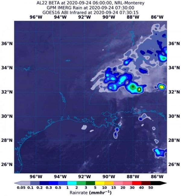
NASA’s Integrated Multi-satellitE Retrievals for GPM or IMERG, which is a NASA satellite rainfall product, estimated on Sept. 24 at 3:30 a.m. EDT (0730 UTC), Beta was generating as much as 10 to 15 mm (0.40 to 0.60 inches) of rain per hour over Alabama. Lighter rainfall rates were occurring over Mississippi and Tennessee at the time of the image. Rainfall throughout most of the storm was estimated as falling at a rate between 0.2 and 1 mm (0.007 to 0.4 inches) per hour.
Read more at NASA/Goddard Space Flight Center
Image: NASA's IMERG estimated on Sept. 24 at 3:30 a.m. EDT (0730 UTC), that Beta was generating as much as 10 to 15 mm (0.40 to 0.60 inches) of rain per hour over Alabama. Lighter rainfall rates were occurring over Mississippi and Tennessee at the time of the image. Rainfall throughout most of the storm was estimated as falling at a rate between 0.2 and 1 mm (0.007 to 0.4 inches) per hour. The rainfall data was overlaid on infrared imagery from NOAA's GOES-16 satellite. (Credit: NASA/NOAA/NRL)


