
A new digital geologic map of the greater Portland-Vancouver-Hillsboro metropolitan area of Oregon and Washington being released today will support emergency response, conservation, agriculture and recreation.
A new digital geologic map of the greater Portland-Vancouver-Hillsboro metropolitan area of Oregon and Washington being released today will support emergency response, conservation, agriculture and recreation.
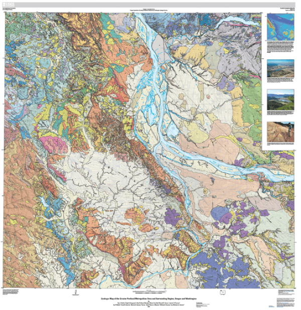
The U.S. Geological Survey’s bi-state map, which covers more than 2500 square miles and would measure 13-feet wide if printed in full, provides geologic information essential for evaluating natural hazards, resources and land use. The map was produced in cooperation with the Oregon Department of Geology and Mineral Industries and the Washington Geological Survey and is based on decades of field and laboratory work by 14 geoscientists from the USGS, Portland State University, Oregon State University and DOGAMI.
“Many believe that we’ve mapped all the geology in the country,” said USGS Director Jim Reilly. “As in all things, maps benefit from a better understanding of the details whether they be in the differences in the geologic units themselves or better precision in how we visualize the terrains. The new mapping will give a more detailed view of the geological conditions in the area for local managers and agencies charged with characterizing and managing resources and hazards. It also provides important information for members of the public seeking recreational sites and in understanding some of what defines why the area is one of our nation’s premier wine-making regions.”
Underpinning the map is a modern geologic database for the greater Portland metro area delineating its tectonic setting, active faults, volcanoes, landslide hazards and distribution of geologic materials.
Continue reading at USGS.
Image via USGS.


