
Before 2020, only four category 4 or 5 hurricanes had ever made landfall in Nicaragua. Now two are going to land in just two weeks.
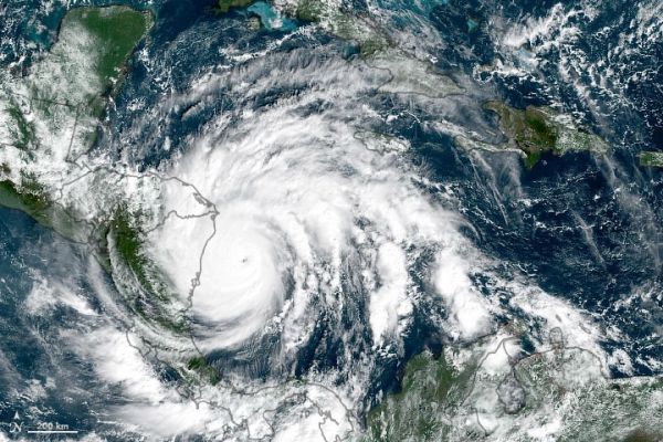
Less than two weeks after being hit by category 4 Hurricane Eta, several Central American countries braced for the arrival of category 5 Hurricane Iota. The U.S. National Hurricane Center (NHC) warned of potentially devastating storm surges and winds, along with torrential rain that will fall upon areas already coping with damaged levees and swollen lakes, reservoirs, and rivers. Iota appeared headed for landfall late on November 16 in northern Nicaragua, likely within tens of kilometers from where Eta hit on November 3, 2020.
Iota is the strongest hurricane and 30th named storm of the 2020 Atlantic season, the most since modern record-keeping began. (The previous record of 28 was set in 2005.) It also marked the first time that two hurricanes have formed in the Atlantic in any November. Iota is the 13th storm to reach hurricane strength this year; the average hurricane year brings 11.5 named storms and six hurricanes.
As of 1 p.m. U.S. Eastern Time on November 16, the NHC had issued hurricane warnings for large portions of coastal Nicaragua and Honduras. Iota had strengthened to a category 5 storm, with sustained winds of 260 kilometers (160 miles) per hour. Forecasters warned of coastal storm surges as high as 4.5 to 6 meters (15 to 20 feet) and rainfall amounts between 250 to 750 millimeters (10 to 30 inches) across parts of Nicaragua, Honduras, Guatemala, and Belize.
Continue reading at NASA Earth Observatory
Image via NASA Earth Observatory


