
A few wet years have helped reverse a decades-long decline in water levels on one of the world’s most cherished lakes.
The Sea of Galilee in northern Israel—one of the lowest-lying bodies of water in the world—has long been a source of religious inspiration and intrigue. It was along the shores of the shallow freshwater lake where the Christian gospels say Jesus performed some of his ministry and certain miracles. Jewish settlers established the first kibbutz nearby. And it appears in certain Islamic prophesies.
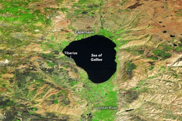
The Operational Land Imager (OLI) on Landsat 8 captured this false-color image (bands 6-5-4) of the lake and its surrounding landscape on October 27, 2020. The image was overlaid on a digital elevation model from the Shuttle Radar Topography Mission (SRTM) to give a sense of the topography.
Some underground springs drain into the lake, but most of its water arrives through the Jordan River, which flows from Lebanon in the north to Israel and Jordan in the south. The Sea of Galilee (sometimes called Lake Tiberias or Lake Kinneret) lies within the Jordan Rift Valley, a narrow depression that began forming tens of millions of years ago as the Arabian plate tore away from Africa. Many of the marshy floodplains around the lake and to the south have been converted into farmland, which appears bright green.
Continue reading at NASA Earth Observatory
Image via NASA Earth Observatory


