
Scientists at NASA's Langley Research Center in Hampton, Virginia, are breaking out their 3D glasses — not to watch the latest blockbuster movie, but to get a more detailed look at blockbuster storm clouds, and ultimately, a better understanding of severe weather.
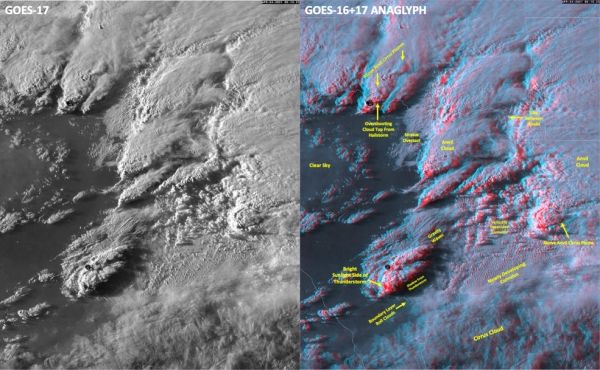
Following a severe storm outbreak that brought large hail, high winds and tornadoes to parts of Texas and Oklahoma on April 23 and 24, Langley scientists Kris Bedka and Konstantin Khlopenkov collaborated to create a 3D composite loop of satellite imagery collected by the National Oceanic and Atmospheric Administration's GOES-17 and GOES-16 satellites (visible above). GOES-17 is in a geostationary orbit (high Earth orbit that allows satellites to match Earth's rotation) southeast of Hawaii and GOES-16 is in a geostationary orbit approximately due south of Virginia's Hampton Roads region.
Though the method for achieving the 3D effect was fairly complex, in the simplest terms it involved applying the western satellite visible wavelength imagery to the red spectrum and the eastern imagery to the blue-green spectrum, then overlaying those images into a single image, or anaglyph, that viewers can see with traditional red-blue 3D glasses.
"Combining imagery from multiple angles gives us the third dimension we don't have with just one satellite," said Bedka.
Continue reading at NASA Langley Research Center
Image via NASA Langley Research Center


