
More than 40 wildfires were burning across the Canadian province by the end of June 2021, including a cluster of substantial blazes located about 200 kilometers northeast of Vancouver.
So far in 2021, British Columbia has already seen dangerous wildfires and heat. More than 40 wildfires were burning across the Canadian province by the end of June 2021, including a cluster of substantial blazes located about 200 kilometers northeast of Vancouver.
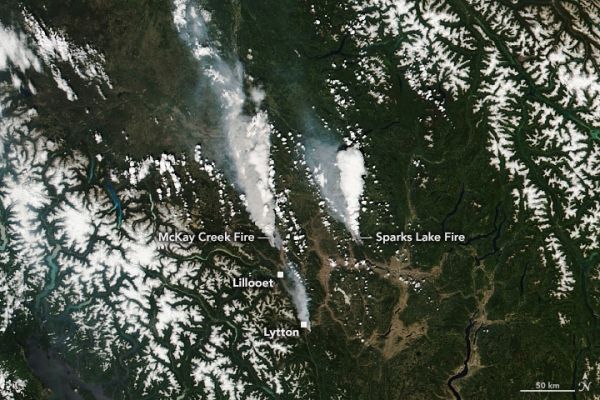
The Visible Infrared Imaging Radiometer Suite (VIIRS) on the NOAA-20 satellite acquired this image (above) around 2 p.m. local time (21:00 Universal Time) on June 30, 2021. By the morning of July 1, the McKay Creek fire (left) and the Sparks Lake fire (right) had burned an estimated 150 and 200 square kilometers (60 and 75 square miles), respectively. A smaller fire is visible just south of the town of Lytton.
Notice the bright white areas over the two larger fires. According to Michael Fromm, a meteorologist with the Naval Research Laboratory, these are the onset of pyrocumulonimbus (pyroCb) clouds—towering clouds created by the convection and heat rising from a fire. The clouds are a mixture of brown smoke and white ice, so they show up whiter than the dry smoke plumes to the west of each fire.
Continue reading at NASA Earth Observatory
Image via NASA Earth Observatory


