
As the Cumbre Vieja eruption continued into its second week, satellites captured images of some remarkable moments in the skies above the volcano.
Since the Cumbre Vieja volcano began erupting on September 19, 2021, most of the compelling activity has happened on the ground. For nearly two weeks, thick sheets of lava burned through farmland, roads, and homes on the southwestern part of La Palma, one of the Canary Islands.
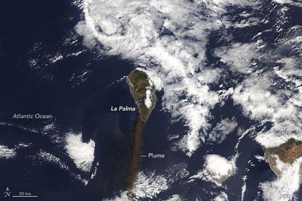
The atmospheric effects of the eruption had been less dramatic until the Canary Islands Volcanology Institute (INVOLCAN) reported an increase in explosive activity that started on October 2. In the midst of the elevated activity, the Moderate Resolution Imaging Spectroradiometer (MODIS) on NASA’s Terra satellite captured an image (above) of a dense plume of ash streaming south on October 4, 2021.
According to the Toulouse Volcanic Ash Advisory Center, the plume reached 3 kilometers (2 miles) on October 4, posing a hazard to aircraft in the area. Despite the increase in activity, volcanologists still rank Cumbre Vieja’s explosivity as “moderate”—a 2 out of 8 on the Volcanic Explosivity Index.
Continue reading at NASA Earth Observatory
Image via NASA Earth Observatory


