
The larch forests of the Republic of Sakha (Yakutia) are like no other place on Earth.
The larch forests of the Republic of Sakha (Yakutia) are like no other place on Earth. Found in a region with some of the world’s largest seasonal temperature swings, these boreal forests are dominated by a deciduous conifer called Larix gmelinii. This hardy type of larch is capable of withstanding temperatures as low as -70°C (-94°F) and surviving in frozen permafrost soils—traits that have given the tree the most northerly range on the planet.
In summer 2021, huge fires raged through these larch forests for months. During Sakha’s most severe fire season in decades, more than 8.4 million hectares of forests burned. “That’s an amazing amount—nearly four times the average,” said Amber Soja, a NASA and National Institute of Aerospace associate research fellow who has conducted field research in the region. It’s also record-breaking. More forest area burned in Sakha than in any year since the Moderate Resolution Imaging Spectroradiometer (MODIS) on NASA’s Terra satellite began collecting data in 2000.
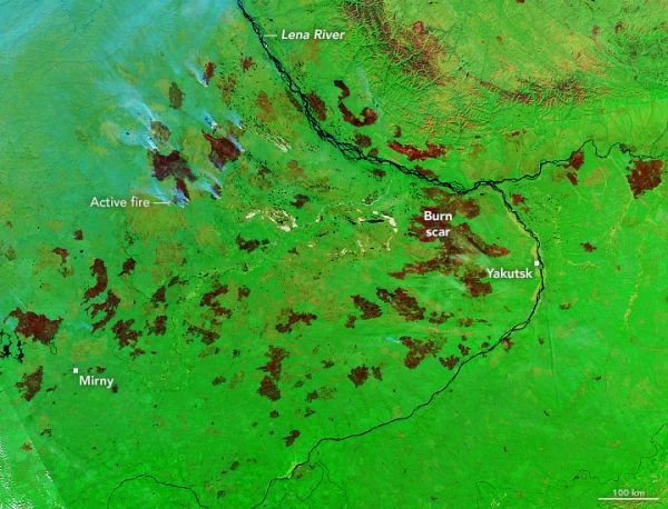
In the false-color satellite image above, burned areas appear dark brown. Unburned areas are green. Patches of green within burn scars are fire refugia—areas within fire perimeters that were unburned or only lightly burned. The Visible Infrared Imaging Radiometer Suite (VIIRS) on the Suomi NPP satellite captured the image on September 10, 2021.
Read more at NASA Earth Observatory
Image: In the false-color satellite image above, burned areas appear dark brown. Unburned areas are green. Patches of green within burn scars are fire refugia—areas within fire perimeters that were unburned or only lightly burned. (NASA Earth Observatory image by Lauren Dauphin, using MODIS data from NASA EOSDIS LANCE and GIBS/Worldview)


