
They’ve delivered groceries and performed light shows at the Olympics.
They’ve delivered groceries and performed light shows at the Olympics. But in the unforgiving Arctic climate, drones have struggled to fly for extended periods of time — the kind that would allow researchers to fly scientific instruments safely to keep tabs on the region.
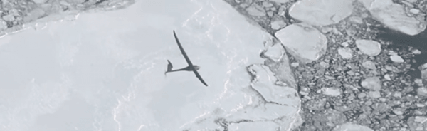
Now, a team led by NASA scientists is showing how a fixed-winged drone named Vanilla could fly for several days over the Arctic ocean carrying an instrument that uses radar to measure the depth of snow accumulating on top of sea ice.
By testing the drone and snow radar instrument together, the team wants to provide key data to more accurately track and project how Earth’s polar regions are changing and influencing sea level.
Because snowfall puts an additional layer of snow over sea ice, even some of NASA’s most powerful altimeter systems in space struggle to measure the thickness of the ice. Data from drones flying at low altitudes can help scientists measure this changing thickness more accurately as Arctic sea ice waxes and wanes with the seasons.
“The same technique could eventually be used to assess how freshwater melting from Greenland and Antarctica contributes to sea level rise,” says Brooke Medley, a research scientist at NASA’s Goddard Space Flight Center in Greenbelt, Maryland, who leads the project.
In other words, Medley sees in drones, a path toward increasingly accurate projections of how sea level rise might reshape coastlines worldwide, and, for more temperate climates, a promising new tool to monitor wildfires, algal blooms, and other vital signals of change on Earth.
Read more at: NASA Goddard Space Flight Center
Vanilla flying over sea ice off Alaska’s North Slope in November 2021. Airborne campaigns to the polar regions often fly straight tracks, limited by the need to refuel in between flights. Drones like Vanilla have different needs, and can offer a niche in Earth observations that scientists have traditionally struggled to explore with boots on the ground or instruments already in the air and space. (Photo Credit: Platform Aerospace)


