
When the low-pressure system dubbed Bernd decided to park itself over part of Central Europe in the summer of 2021, the hazards associated with excessive rainfall events were made dramatically apparent in the form of the resultant catastrophic flooding.
When the low-pressure system dubbed Bernd decided to park itself over part of Central Europe in the summer of 2021, the hazards associated with excessive rainfall events were made dramatically apparent in the form of the resultant catastrophic flooding. Weather records show that extreme natural occurrences such as drought, but also heavy rainfall and hail storms, are likely to occur even more frequently in this part of the world as a result of climate change. And their consequences could become even more devastating. Hailstones, for example, can cause damage to crops, vehicles, and buildings and they can be dangerous for exposed humans and animals, too. It is thus all the more important that weather models are capable of most accurately predicting the possibility and extent of any such precipitation. For this, the numerical weather models must be based on precisely formulated mathematical interpretations of the physical processes in clouds.
The vertical wind tunnel at Johannes Gutenberg University Mainz (JGU), which is the only one of its kind in the world, is providing essential information in this connection through new experiments that are being conducted using artificial hailstones made by a 3D printer. "One thing we have learned so far is that it is the form of hailstones that determines their velocity prior to impact," explained Dr. Miklós Szakáll of the Institute of Atmospheric Physics (IPA) at JGU. Szakáll's team has been able to demonstrate that lobed hailstones develop less kinetic energy and thus less destructive potential than hail with a smooth surface.
Hail and graupel, which is the term used to describe precipitated small, soft ice pellets, are formed when water droplets freeze within storm clouds. This freezing process is promoted by turbulences and complex physical processes in these clouds that can extend to very high altitudes. These ice particles melt if they pass through warmer air layers on the way down. The result is large, cold raindrops and these are often the culprits behind extreme rainfall precipitation. Assuming that the ice particles do not have time to melt completely before reaching the ground, they arrive in the form of hail or graupel.
Read more at: Johannes Gutenberg Universitaet Mainz
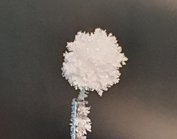
A rimed ice particle, in this case a graupel pellet, created for experimental use in the Mainz vertical wind tunnel. (Photo Credit: ©: Alexander Theis)


