
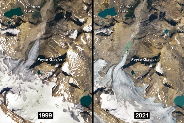
The Peyto Glacier in Canada’s Banff National Park has shrunk by around 70 percent over the last half-century, a dramatic change highlighted in newly released satellite imagery from NASA.
The Peyto Glacier in Canada’s Banff National Park has shrunk by around 70 percent over the last half-century, a dramatic change highlighted in newly released satellite imagery from NASA.
Scientists have assembled a wealth of data on Peyto, which was selected as a reference glacier in 1968 for a UN water research initiative. Researchers have tracked changes in the glacier’s mass over the years to help gauge changes to glaciers worldwide as temperatures rise. In most years, Peyto lost more mass from melting ice than it gained from snowfall.
Satellite images show how the glacier has thinned and retreated, with a lake forming from meltwater at the end of the glacier. Rising summer temperatures have accelerated melting, scientists say, as has soot from nearby wildfires, with the dark soot absorbing more of the sun’s heat. While melting has increased in recent decades, snowfall has stayed roughly the same.
Read more at Yale Environment 360
Image: Peyto Glacier in Canada's Banff National Park in August 1999 and August 2021. (Credit: NASA)


