
The second-largest reservoir in the United States now stands at its lowest level since it was filled in the mid-1960s. The view from above is sobering.
The second-largest reservoir in the United States now stands at its lowest level since it was filled in the mid-1960s. The view from above is sobering.
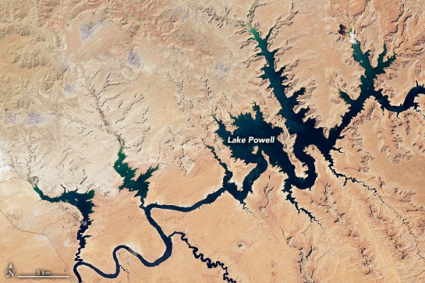
Lake Powell, a key component of the western U.S. water system, is currently filled to just 26 percent of capacity, its lowest point since 1967. On August 22, 2022, the water elevation of the lake surface was 3,533.3 feet, more than 166 feet below “full pool” (elevation 3,700 feet).
The natural-color images on this page show portions of Lake Powell in the summers of 2017 and 2022, as observed by Landsat satellites. The Operational Land Imager on Landsat 8 acquired the 2017 images, while the Operational Land Imager-2 on Landsat 9 acquired the 2022 images. Lake Powell straddles the border of southeastern Utah and northeastern Arizona; most of the area shown is in Utah. (For a year-by-year view, visit the Earth Observatory feature World of Change: Water Level in Lake Powell.)
Read more at: NASA Earth Observatory
Photo Credit: NASA Earth Observatory


