
In the absence of human intervention, most of the forests in the Amazon River basin are too wet to burn. Yet for as long as scientists have observed the region by satellite, they have detected an abundance of fire activity, especially during the driest months of the year.
In the absence of human intervention, most of the forests in the Amazon River basin are too wet to burn. Yet for as long as scientists have observed the region by satellite, they have detected an abundance of fire activity, especially during the driest months of the year. This year has followed that pattern, with especially dense plumes of smoke streaming from fires near settlements and roads in the southern Amazon.
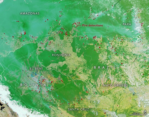
On September 5, 2022, the Moderate Resolution Imaging Spectroradiometer (MODIS) on NASA’s Aqua satellite acquired a natural-color image (above) of smoke over parts of Bolivia and Brazil. Thick smoke emanated from Bolivia’s El Beni and Santa Cruz districts, where forests typically receive less rain than other parts of the Amazon basin. The smoke streamed north and mixed with plumes from fires burning in rainforests in several Brazilian states, including Acre, Amazonas, Rondônia, Pará, and Mato Grosso. Substantial fire activity in 2022 has occurred along key highways, notably BR-163 and the Trans-Amazonian highway in Pará and Amazonas (upper right of image).
The thickest smoke plumes amid the heavily forested (green) areas typically rise from deforestation fires. These are usually lit to dispose of piles of leftover wood, sometimes several months after forests have been bulldozed. Forest clearing for ranching and farming is common in both countries. Smaller smoke plumes in cleared, agricultural areas (brown) are typically grassland fires lit by ranchers and farmers to manage cattle pastures or croplands.
Read more at: NASA Earth Observatory
Photo Credit: NASA Earth Observatory


