
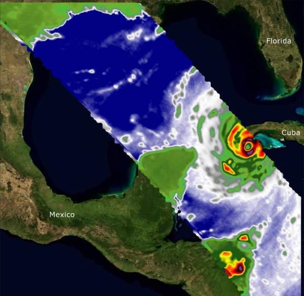
Two recently launched instruments that were designed and built at NASA’s Jet Propulsion Laboratory in Southern California to provide forecasters data on weather over the open ocean captured images of Hurricane Ian on Tuesday, Sept. 27, 2022, as the storm approached Cuba on its way north toward the U.S. mainland.
Two recently launched instruments that were designed and built at NASA’s Jet Propulsion Laboratory in Southern California to provide forecasters data on weather over the open ocean captured images of Hurricane Ian on Tuesday, Sept. 27, 2022, as the storm approached Cuba on its way north toward the U.S. mainland.
COWVR (short for Compact Ocean Wind Vector Radiometer) and TEMPEST (Temporal Experiment for Storms and Tropical Systems) observe the planet’s atmosphere and surface from aboard the International Space Station, which passed in low-Earth orbit over the Caribbean Sea at about 12:30 a.m. EDT.
Ian made landfall in Cuba’s Pinar del Rio province at 4:30 a.m. EDT, according to the National Hurricane Center. At that time, it was a Category 3 hurricane, with estimated wind speeds of 125 mph (205 kph).
The image above combines microwave emissions measurements from both COWVR and TEMPEST. White sections indicate the presence of clouds. Green portions indicate rain. Yellow, red, and black indicate where air and water vapor were moving most swiftly. Ian’s center is seen just off of Cuba’s southern coast, and the storm is shown covering the island with rain and wind.
Read more at: NASA Goddard Space Flight Center
From aboard the International Space Station, NASA-built instruments Compact Ocean Wind Vector Radiometer (COWVR) and Temporal Experiment for Storms and Tropical Systems (TEMPEST) captured wind and water vapor data from Hurricane Ian as the storm neared Cuba. (Photo Credit: NASA/JPL-Caltech)


