
A team of researchers led by the University of Minnesota Twin Cities has released four more years of high-resolution imagery data, which has been added to eight years of previous data, to create the most detailed polar region terrain maps ever created.
A team of researchers led by the University of Minnesota Twin Cities has released four more years of high-resolution imagery data, which has been added to eight years of previous data, to create the most detailed polar region terrain maps ever created. The maps use high-resolution satellite data to show the polar regions in stunning detail and will provide new insights into the effects of climate change over time.
The researchers have partnered with Amazon Web Services to make the high-resolution imagery data publicly available in the cloud for free.
“Our previous data resulted in more than 300 scientific publications,” said Claire Porter, acting co-director of the National Science Foundation-funded Polar Geospatial Center at the University of Minnesota Twin Cities. “With four more years of data that is even more accessible, these are transformative data sets. We’re excited to see what scientists will discover about how our Earth is changing.”
The project began with images taken from a constellation of polar-orbiting satellites about 400-700 kilometers above the Earth. The researchers at the Polar Geospatial Center created the digital elevation models based on 50-centimeter resolution images captured by the commercial satellites owned by Maxar and licensed by the National Geospatial-Intelligence Agency.
Read more at University of Minnesota
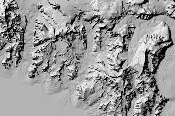
Image: With four more years of satellite imagery data, researchers in the Polar Geospatial Center at the University of Minnesota and their partners have now released the most detailed polar region terrain maps ever created. This image shows a Reference Elevation Model of Antarctica (REMA) of Central Transantarctic Mountain regions in stunning detail. (Credit: Polar Geospatial Center at the University of Minnesota from satellites owned by Maxar and licensed by the National Geospatial-Intelligence Agency)


