
In December 2022, Earth was in the grips of La Niña—an oceanic phenomenon characterized by the presence of cooler than normal sea-surface temperatures in the central and eastern tropical Pacific.
In December 2022, Earth was in the grips of La Niña—an oceanic phenomenon characterized by the presence of cooler than normal sea-surface temperatures in the central and eastern tropical Pacific. The current La Niña, relatively weak but unusually prolonged, began in 2020 and has returned for its third consecutive northern hemisphere winter, making this a rare “triple-dip” event. Other triple-dip La Niña’s recorded since 1950 spanned the years 1998-2001, 1973-1976, and 1954-1956.
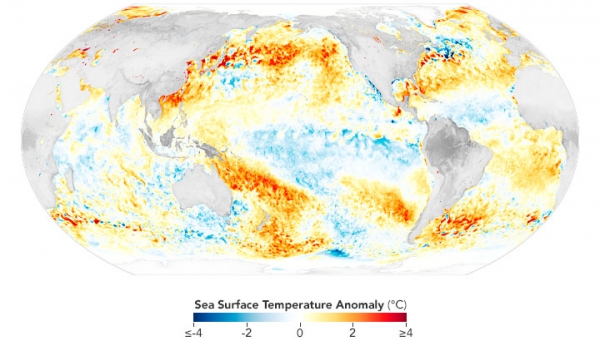
The map above shows sea surface temperature anomalies on November 29, 2022. The signature of La Niña is visible in the central and eastern Pacific Ocean as areas of cooler-than-average water. From the South American coast to the international dateline, surface waters on this day were roughly 1°C (1.8°F) cooler than usual.
Water temperature anomalies that range from -0.5°C to -0.9°C are classified as a “weak” La Niña, -1°C to -1.5°C are “moderate,” and -1.5°C and beyond are “strong.” The data are from the Multiscale Ultrahigh Resolution Sea Surface Temperature (MUR SST) project. MUR SST blends measurements of sea surface temperatures from multiple NASA, NOAA, and international satellites, as well as ship and buoy observations. (Scientists also use instruments floating within the sea to project underwater temperatures.)
Read more at: NASA Earth Observatory
Photo Credit: NASA Earth Observatory


