
Just four days after heavy rain hit California, the state was drenched with another atmospheric river on January 4 and 5, 2023.
Just four days after heavy rain hit California, the state was drenched with another atmospheric river on January 4 and 5, 2023. A plume of moisture from the tropical Pacific interacted with a low-pressure system that rapidly strengthened over the northeast Pacific, producing a storm that caused flooding, toppled trees, and downed power lines.
According to the National Weather Service, coastal areas of California saw wind speeds of 40 to 80 miles per hour. On the evening of January 4, wind speeds exceeded 100 miles per hour near Lake Tahoe. About 1 to 3 inches of rain fell on communities near Santa Cruz and San Francisco on the evening of January 4, but the storm continued to drop rain on the Bay Area as it moved east on January 5. Some areas south of Big Sur saw 6 to 8 inches of rain in 24 hours.
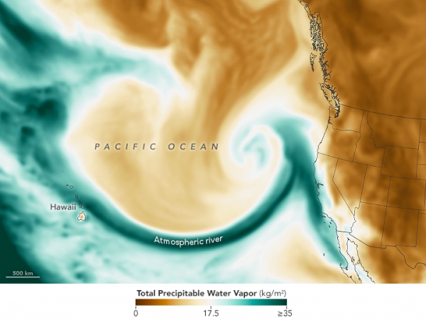
This map shows the total precipitable water vapor in the atmosphere at 5:30 a.m. Pacific Standard Time on January 4, 2023. Precipitable water vapor is the amount of water in a column of the atmosphere if all of the water vapor were condensed into liquid. Dark green areas on the map indicate a narrow band of moisture flowing from the tropical Pacific toward the West Coast, making this atmospheric river an example of a “Pineapple Express.” The image was derived from NASA’s Goddard Earth Observing System, Atmospheric Data Assimilation System (GEOS ADAS), which uses satellite data and models of physical processes to calculate what is happening in the atmosphere.
Read more at: NASA Earth Observatory
Photo Credit: Nature_Design via Pixabay


