
Dartmouth study finds snowpack to shrink, but more rain could raise flood risk.
Dartmouth study finds snowpack to shrink, but more rain could raise flood risk.
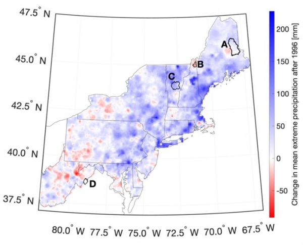
Over the past 25 years, the Northeast has experienced the largest increase in extreme precipitation nationally. Prior research has shown that the amount of extreme precipitation—rain or snow that results in one to two inches of water in a day—over the past 25 years has been almost 50% greater than from 1901 to 1995.
A new Dartmouth study provides insight into how changes in precipitation and temperature due to global warming affect streamflow and flooding in the Northeast. The findings are published in the Journal of the American Water Resources Association.
The researchers examined how precipitation—including snowfall, winter rain on snow events, springtime snowmelt, and soil conditions—impacts streamflow. They focused on four watersheds in the Northeast: the Mattawamkeag River in northeastern Maine; the Dead Diamond River in northern New Hampshire; the White River in eastern Vermont; and the Shenandoah River in West Virginia.
Read more at Dartmouth College
Image: Map showing the average change in annual extreme precipitation 1996-2011 compared to the 1979-1996 average. Watersheds analyzed are outlined in black: (A) Mattawamkeag River in Maine, (B) Dead Diamond River in New Hampshire, (C) White River in Vermont, and (D) Shenandoah River in West Virginia. (Credit: Figure by C.Cockburn et al.)


