
NASA-NOAA’s Suomi NPP satellite and the GPM core satellite passed over Tropical Cyclone Gita is it began weakening from vertical wind shear.
Warnings and watches are in effect for New Caledonia and Zealand is on alert for Tropical Cyclone Gita. In New Caledonia, the majority of the territory is on pre-alert with the exception of the Ile des Pins, which is on Alert #2. New Zealand is expected to be affected by Gita on February 19 and 20 and the meteorological service is tracking the storm.
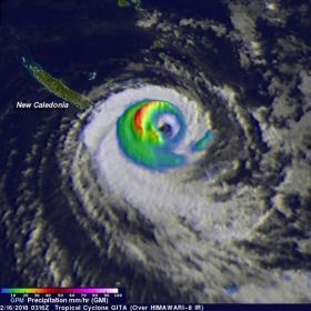
The Global Precipitation Measurement mission or GPM core observatory satellite's Microwave Imager (GMI) instrument had a fairly good view of Tropical Cyclone Gita on February 16, 2018 at 0316 UTC (Feb. 15 at 10:16 a.m. EST). GPM's Dual Frequency Precipitation Radar (DPR) swath only covered the area west of GITA's main area of precipitation. The weakening tropical cyclone was passing the southeastern tip of New Caledonia. Although weakening, Gita still had winds estimated at over 90 knots (104 mph). Rainfall derived from GMI data showed that the heaviest precipitation, falling at rate of about 51 mm (2 inches) per hour, was shown west of Gita's eye. GPM is a joint mission between NASA and the Japan Aerospace Exploration Agency, JAXA.
On Feb. 16 at 0206 UTC (Feb. 15 at 9:06 p.m. EST) the Visible Infrared Imaging Radiometer Suite (VIIRS) instrument aboard NASA-NOAA's Suomi NPP satellite showed the eye of Gita southeast of New Caledonia. Some high level clouds have filled in the eye, but it was still quite visible in the VIIRS image.
Read more at NASA/Goddard Space Flight Center
Image: On Feb. 16, GPM data showed that the heaviest precipitation, falling at rate of about 51 mm (2 inches) per hour, was shown west of Gita's eye. (Credit: NASA/JAXA, Hal Pierce)


