
As Tropical Storm Kirk came back to life, the Global Precipitation Measurement mission or GPM core satellite analyzed its rainfall. Kirk is headed toward the Lesser Antilles and Warnings are in effect.
As Tropical Storm Kirk came back to life, the Global Precipitation Measurement mission or GPM core satellite analyzed its rainfall. Kirk is headed toward the Lesser Antilles and Warnings are in effect.
On Sept. 27, the National Hurricane Center or NHC posted a Tropical Storm Warning for Barbados, St. Lucia, Dominica, Martinique, and Guadeloupe. A Tropical Storm Watch is in effect for St. Vincent and the Grenadines.
On Sept. 25 tropical storm Kirk seemed to be dissipating but on Sept. 26 the tropical storm has sprung back to life. Convective activity near the center of tropical storm Kirk’s remnants increased and became better organized.
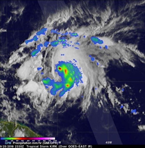
The GPM core observatory satellite scanned reviving tropical storm Kirk on September 25, 2018 at 7:35 p.m. (2335 UTC). Data collected by the satellite’s Microwave Imager (GMI) instrument showed that intense convective precipitation was taking place near the center of the reviving tropical storm. GMI’s scans indicated that rain was falling at over 71 mm (2.8 inches) in some of these storms. GPM’s Dual-Frequency Precipitation Radar (DPR) probed storms that were located to the east and northeast of the center of the regenerating tropical storm. DPR found rain there falling at a rate of over 69 mm (2.7 inches) per hour.
Read more at NASA/Goddard Space Flight Center
Image: The GPM core observatory satellite scanned reviving tropical storm Kirk on September 25, 2018 at 7:35 p.m. (2335 UTC). Rain was falling at over 71 mm (2.8 inches) in storms around the center. Storms located to the east and northeast of the center of the regenerating tropical storm had rainfall at a rate of over 69 mm (2.7 inches) per hour. (Credit: NASA/JAXA, Hal Pierce)


