
Tropical Storm Fani formed in the Northern Indian Ocean over the weekend of April 27 and 28.
Tropical Storm Fani formed in the Northern Indian Ocean over the weekend of April 27 and 28. The Global Precipitation Measurement mission or GPM core satellite passed over the storm and measured rainfall occurring throughout the new storm.
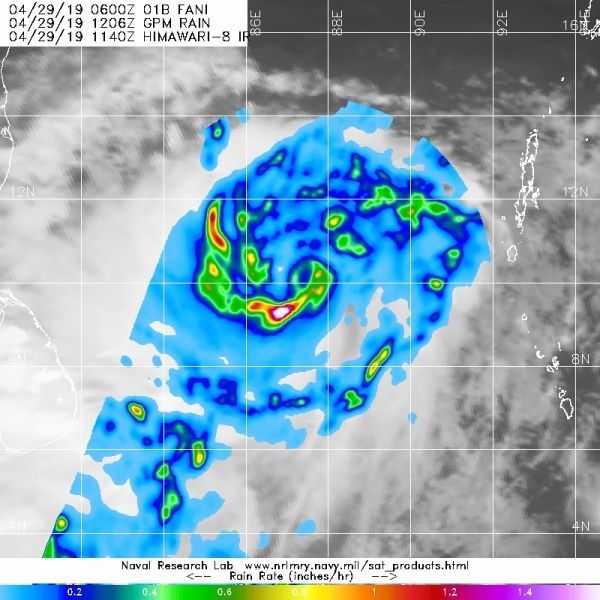
GPM’s core satellite flew over Tropical Cyclone Fani at 8:06 a.m. EDT (1206 UTC) on April 29 and found the heaviest rainfall was in an area south of the center of circulation. There rain was falling at a rate of about 1.6 inches (40 mm) per hour. Rainfall was occurring at rate around 1 inch (25 mm) per hour in bands of thunderstorms circling the center. GPM is a joint mission between NASA and the Japan Aerospace Exploration Agency, JAXA.
The Joint Typhoon Warning Center noted, “Animated enhanced infrared satellite imagery reveals significant consolidation in the convective structure and a better idea of the location of the low-level circulation center. There is high confidence in the initial position based on an eye feature in a microwave satellite image.”
Read more at NASA / Goddard Space Flight Center
Image: The GPM core satellite passed over Tropical Storm Fani at 8:06 a.m. EDT (1206 UTC) on April 29. GPM found the heaviest rainfall (pink) was in an area south of the center of circulation. There rain was falling at a rate of about 1.6 inches (40 mm) per hour. Rainfall was occurring at rate around 1 inch (25 mm) per hour in bands of thunderstorms circling the center. CREDIT: NASA/JAXA/NRL


