
Tropical Storm Mitag was dropping heavy rainfall along coastal areas of South Korea and lighter rainfall over the entire country.
Tropical Storm Mitag was dropping heavy rainfall along coastal areas of South Korea and lighter rainfall over the entire country. The Global Precipitation Measurement mission or GPM satellite provided a look at the rainfall occurring from the system.
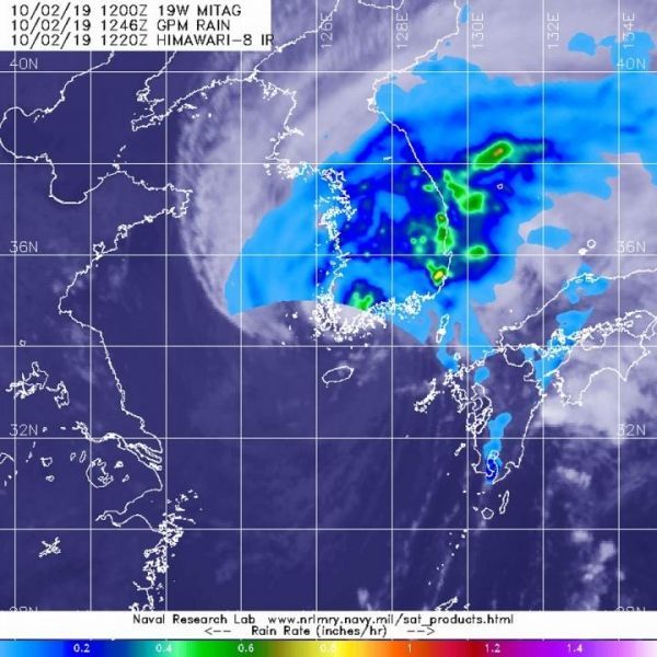
The GPM’s core satellite passed over Tropical Storm Mitag on Oct. 2 at 8:46 a.m. EDT (1246 UTC). GPM found heaviest rain falling in scattered areas over the eastern and southern coasts of South Korea and over the Sea of Japan. GPM found light rain falling over the rest of South Korea at around 0.2 inches (5 millimeters) per hour.
On Oct. 2 at 11 a.m. EDT (1500 UTC), Mitag was located near latitude 34.4 degrees north and longitude 126.3 degrees west. Mitag was centered about 91 nautical miles south of Kunsan Air Base, South Korea. Maximum sustained winds have decreased to near 40 knots (46 mph/74 kph) and are weakening.
Read more at: NASA/Goddard Space Flight Center
The GPM's core satellite passed over Tropical Storm Mitag on Oct. 2, 2019 at 8:46 a.m. EDT (1246 UTC). GPM found heaviest rain (orange) falling in scattered areas over the eastern and southern coasts of South Korea and Sea of Japan. GPM found light rain (light blue) falling over the rest of South Korea at around 0.2 inches (5 millimeters) per hour. Japan's Himawari-8 satellite provided the cloud imagery. (Photo Credit: NASA/NRL)


