
The Global Precipitation Measurement mission or GPM satellite provided a look at the rainfall occurring within Tropical Cyclone Uesi and found heaviest rainfall in the southern quadrant of the storm.
The Global Precipitation Measurement mission or GPM satellite provided a look at the rainfall occurring within Tropical Cyclone Uesi and found heaviest rainfall in the southern quadrant of the storm.
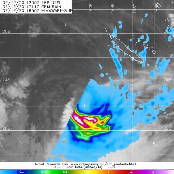
Uesi is in the South Pacific Ocean and has been affecting New Caledonia. New Caledonia is a collectivity of France, located south of Vanuatu and about 1,210 km (750 miles) east of Australia.
The GPM’s core satellite passed over Uesi on Feb. 12 at 12:11 p.m. EST (1711 UTC). GPM found heaviest rainfall southwest of the center, falling at a rate of 1.6 inches (40 mm) per hour. Directly south of the center were areas where rainfall rates were falling at a rate of 1 inch (25 mm) per hour. Scattered light rain, falling at less than 0.2 inches (less than 5 millimeters) per hour appeared to be occurring in the rest of the storm.
On Feb 12 at 1 a.m. EST (5 p.m. New Caledonia local time), Meteo-France, which forecasts for New Caledonia, noted that Uesi’s maximum sustained winds were near 110 kph (68 mph/59 knots). Uesi was moving to the southwest. It was centered near latitude 23.5 degrees south and longitude 162.8 degrees east, about 450 km (280 miles) west-southwest of Noumea.
Read more at NASA/Goddard Space Flight Center
Image: The GPM's core satellite passed over Uesi on Feb. 12 at 12:11 p.m. EST (1711 UTC). GPM found heaviest rainfall (pink) southwest of the center, falling at a rate of 1.6 inches (40 mm) per hour. Orange areas indicate rainfall rates of 1 inch (25 mm) per hour and scattered light rain appears in light blue from the fringe clouds falling at less than 0.2 inches (less than 5 millimeters) per hour. The GPM rainfall was overlaid on imagery from Japan's Himawari-8 satellite. (Credit: NASA/NRL/JAXA)


