
NASA’s Aqua satellite used infrared light to analyze the strength of storms in the North Atlantic Ocean’s newly formed Subtropical Depression 4.
NASA’s Aqua satellite used infrared light to analyze the strength of storms in the North Atlantic Ocean’s newly formed Subtropical Depression 4. Infrared data provides temperature information to find the strongest thunderstorms that reach high into the atmosphere which have the coldest cloud top temperatures.
By 5 p.m. EDT on Monday, June 22, the non-tropical low-pressure system that the National Hurricane Center had been following for the past couple of days off the U.S. east coast had developed enough organized convection near the center to be classified as subtropical depression. It was then that Subtropical Depression 4 was born.
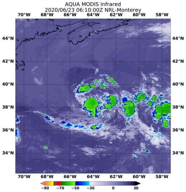
The Moderate Resolution Imaging Spectroradiometer or MODIS instrument aboard NASA’s Aqua satellite captured infrared data on June 23 at 2:10 a.m. EDT (0610 UTC). The MODIS data showed several fragmented and disorganized thunderstorms circling the center of circulation where cloud top temperatures as cold as or colder than minus 50 degrees Fahrenheit (minus 45.5 Celsius). Cloud top temperatures that cold indicate strong storms with the potential to generate heavy rainfall.
On June 23 at 2:10 a.m. EDT (0610 UTC), NASA's Aqua satellite found several fragmented and disorganized thunderstorms circling the center of circulation of Subtropical Depression 4, where cloud top temperatures as cold as or colder than minus 50 degrees Fahrenheit (minus 45.5 Celsius). (Photo Credit: Credit: NASA/NRL)
Read more at: NASA/Goddard Space Flight Center


