
In mid-April 2026, Super Typhoon Sinlaku churned across the North Pacific Ocean and brought heavy rain and flooding to the Mariana Islands.
In mid-April 2026, Super Typhoon Sinlaku churned across the North Pacific Ocean and brought heavy rain and flooding to the Mariana Islands. The storm reached “violent typhoon” status—the highest intensity on the scale used by the Japan Meteorological Agency and roughly equivalent to a category 5 storm on the Saffir-Simpson wind scale. Sinlaku was one of only a handful of tropical cyclones of that intensity known to have occurred so early in the year in the region, meteorologists noted.
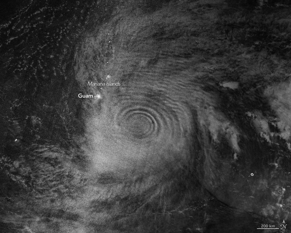
Sinlaku rapidly intensified over the ocean before its impacts reached land. Around the time of this strengthening, satellites began to detect that the typhoon’s effects also extended upward, into the upper atmosphere.
The nighttime image above, acquired with the VIIRS (Visible Infrared Imaging Radiometer Suite) on the NOAA-20 satellite, shows atmospheric gravity waves radiating from the typhoon. These waves, resembling ripples on a pond, were made visible to the sensor via airglow in the mesosphere. Airglow occurs when atoms and molecules, excited by sunlight during the day, later emit light to release excess energy.
Read More: NASA Earth Observatory
Image: Atmospheric gravity waves generated by Super Typhoon Sinlaku are visible via mesospheric airglow in this nighttime image acquired with the VIIRS (Visible Infrared Imaging Radiometer Suite) on the NOAA-20 satellite on April 12, 2026, Universal Time (April 13 local time). NASA Earth Observatory/Michala Garrison


