
In May and June of most years, NASA satellites typically begin to detect large numbers of wildland fires throughout the Top End and Arnhem Land regions of Australia’s Northern Territory.
In May and June of most years, NASA satellites typically begin to detect large numbers of wildland fires throughout the Top End and Arnhem Land regions of Australia’s Northern Territory. On some days, especially in the afternoon, the blazes can resemble sizable wildfires in satellite imagery, spreading widely and producing expansive smoke plumes.
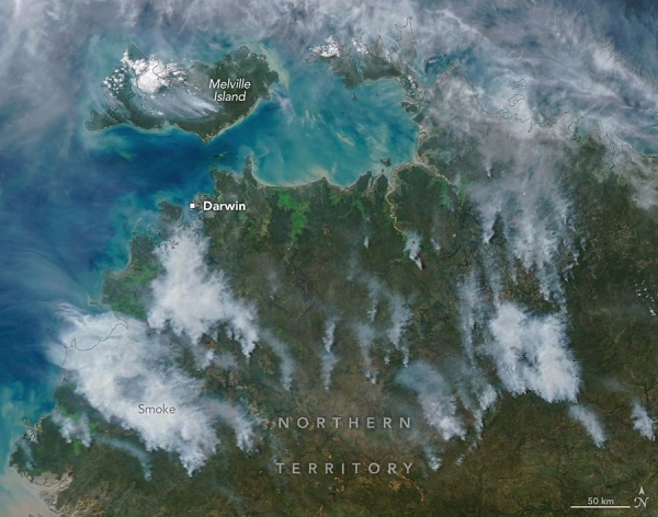
That was the case when NASA's Aqua satellite acquired this image of smoke and fires on the afternoon of May 28, 2026. Often, however, fires burning in this area look smaller and less imposing. In the mornings just a few days earlier and later, for instance, NASA satellites detected little smoke despite observing many thermal anomalies, or hotspots, that indicated fire activity.
The pattern of burning, location, and timing are consistent with prescribed fires lit intentionally to manage the landscape. Land managers tend to light fires in the morning, and smoke builds over the course of the day. The process sometimes creates sizable plumes when there are updrafts and winds of moderate strength that carry smoke away from the fires, as happened on May 28 and again on June 2. The fires typically burn through the fire-adapted grasses, underbrush, and scattered trees in the region's tropical savanna ecosystems.
Read More: National Aeronautics and Space Administration (NASA)
Image: Smoke streams from fires in Australia’s Northern Territory in an image captured by the MODIS (Moderate Resolution Imaging Spectroradiometer) on NASA's Aqua satellite on May 28, 2026. (Credit: NASA Earth Observatory/Michala Garrison)


